
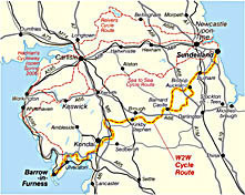
Walney to Wear Cycle Route
This is probably the least cycled of the coast to coast cycle routes linking the Cumbrian coast and the North East, but an extremely good route. 153 miles of coast and hills, and joining the far end of the C2C.
The route starts near Barrow-in-Furness in south Cumbria and skirts the Lake District. It snakes through the Pennines to finish at Sunderland.
Walney to Wear Cycle Route Map
The map is unfortunately currently out of print. Once it is back in print, we will put it back on the website.
In the meantime, there are the pocket-sized Sustrans maps which can be used to follow it. You would need South Cumbria; County Durham; then depending on your finish point, either Tyne & Wear or North York Moors.
I have cycled part of the route, and it is highly recommended. Suggest you get maps though!
Or pop the various maps in your basket below.
